Layers in Blazor Maps Component
23 Jun 20264 minutes to read
The Maps component is rendered through MapsLayers, and any number of layers can be added to Maps.
Multilayer
The multilayer feature supports loading multiple shape files and map providers in a single container, enabling Maps to display more information. The shape layer or map providers are the main layers. Multiple layers can be added as a SubLayer over the main layers using the Type property in MapsLayer.
Sublayer
Sublayer is a type of shape file layer. It supports loading multiple shape files in a single map view. For example, a sublayer can be added over the main layer to display geographic features such as rivers, valleys, and cities in a country map. Similar to the main layer, elements such as markers, bubbles, color mapping, and legends can be added to the sublayer.
In the following example, the United States map shape is used as shape data from the usa.ts file, and texas.ts and california.ts files are used as sublayer in the United States map.
@using Syncfusion.Blazor.Maps

<SfMaps>
    <MapsLayers>
        <MapsLayer ShapeData='new {dataOptions ="https://cdn.syncfusion.com/maps/map-data/usa.json"}' TValue="string">
            <MapsShapeSettings Fill="#E5E5E5">
                <MapsShapeBorder Color="black" Width="0.1"></MapsShapeBorder>
            </MapsShapeSettings>
        </MapsLayer>
        <MapsLayer ShapeData='new {dataOptions = "https://cdn.syncfusion.com/maps/map-data/texas.json"}'
	        Type="Syncfusion.Blazor.Maps.Type.SubLayer" TValue="string">
            <MapsShapeSettings Fill="rgba(141, 206, 255, 0.6)">
                <MapsShapeBorder Color="#1a9cff" Width="0.25"></MapsShapeBorder>
            </MapsShapeSettings>
        </MapsLayer>
        <MapsLayer ShapeData='new {dataOptions= "https://cdn.syncfusion.com/maps/map-data/california.json"}'
	        Type="Syncfusion.Blazor.Maps.Type.SubLayer" TValue="string">
            <MapsShapeSettings Fill="rgba(141, 206, 255, 0.6)">
                <MapsShapeBorder Color="#1a9cff" Width="0.25"></MapsShapeBorder>
            </MapsShapeSettings>
        </MapsLayer>
    </MapsLayers>
</SfMaps>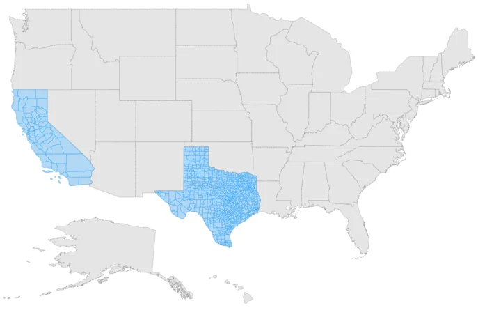
Displaying different layer in the view
Multiple shape files and map providers can be loaded simultaneously. The BaseLayerIndex property determines which layer is displayed. This property also supports the drill-down feature; when the BaseLayerIndex value changes, the corresponding shape is loaded. In this example, two layers are configured for the world map and the United States map. Based on the BaseLayerIndex value, the corresponding shape is rendered. If BaseLayerIndex is set to 0, the world map is loaded.
@using Syncfusion.Blazor.Maps

@*  To switch the layer, set `BaseLayerIndex`  *@
<SfMaps BaseLayerIndex="1">
    <MapsLayers>
        <MapsLayer ShapeData='new { dataOptions = "https://cdn.syncfusion.com/maps/map-data/world-map.json" }' TValue="string"/>
        <MapsLayer ShapeData='new { dataOptions = "https://cdn.syncfusion.com/maps/map-data/usa.json" }'TValue="string"/>
    </MapsLayers>
</SfMaps>
Rendering custom shapes
Custom shapes (also known as custom maps) can be rendered in Maps to represent bus seat booking, cricket stadiums, basic home plans/sketches, and similar layouts. To achieve this, create a JSON file in GeoJSON format with proper geometries manually or with an online map vendor. Set the created GeoJSON file to the ShapeData property in the Maps layer, and set GeometryType to GeometryType.Normal.
Refer to the sample GeoJSON file for bus seat selection: Seat selection GeoJSON.
For a live demonstration, see Bus seat selection demo.