Polygon shape in Blazor Maps Component
23 Jun 202620 minutes to read
The Maps component supports adding polygon shapes to a geometry map or an online map using the properties of the MapsPolygon tag. This section explains how to add polygon shapes to the map and customize them.
Adding polygon shape
A polygon shape can be rendered over the map layer by defining the Points property in the MapsPolygon tag in the Maps component. The Points property uses a collection of latitude and longitude values to define the polygon shape.
The MapsPolygon tag supports the following properties for polygon appearance and styling:
- Fill - Changes the color of the polygon shape.
- Opacity - Changes the opacity of the polygon shape.
- BorderColor - Changes the color of the polygon border.
- BorderWidth - Changes the width of the polygon border.
- BorderOpacity - Changes the opacity of the polygon border.
Multiple polygon shapes can be included inside the MapsPolygons tag.
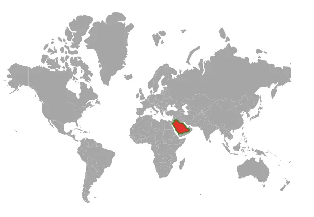
The following example demonstrates customizing a polygon on a geometry map.
@using Syncfusion.Blazor.Maps

<SfMaps>
    <MapsLayers>
        <MapsLayer ShapeData='new {dataOptions= "https://cdn.syncfusion.com/maps/map-data/world-map.json"}' TValue="string">
            <MapsPolygons>
                <MapsPolygon Points="Points" Fill="red" Opacity="0.7" BorderColor="green" BorderWidth="2" BorderOpacity="0.7"></MapsPolygon>
            </MapsPolygons>
        </MapsLayer>
    </MapsLayers>
</SfMaps>

@code {
    List<Coordinate> Points = new List<Coordinate>();

    protected override async Task OnInitializedAsync()
    {
        await base.OnInitializedAsync();
        Points.Add(new Coordinate() { Longitude = 34.88539587371454, Latitude = 28.181421087099537 });
        Points.Add(new Coordinate() { Longitude = 37.50029619722466, Latitude = 24.299419888989462 });
        Points.Add(new Coordinate() { Longitude = 39.22241423764024, Latitude = 22.638529461838658 });
        Points.Add(new Coordinate() { Longitude = 38.95650769309776, Latitude = 21.424998160017495 });
        Points.Add(new Coordinate() { Longitude = 40.19963938650778, Latitude = 20.271205391339606 });
        Points.Add(new Coordinate() { Longitude = 41.76547269134551, Latitude = 18.315451049867193 });
        Points.Add(new Coordinate() { Longitude = 42.78452077838921, Latitude = 16.097235052947966 });
        Points.Add(new Coordinate() { Longitude = 43.36984949591576, Latitude = 17.188572054533054 });
        Points.Add(new Coordinate() { Longitude = 44.12558191797012, Latitude = 17.407258102232234 });
        Points.Add(new Coordinate() { Longitude = 46.69027032797584, Latitude = 17.33342243475734 });
        Points.Add(new Coordinate() { Longitude = 47.09312386141585, Latitude = 16.97087769526452 });
        Points.Add(new Coordinate() { Longitude = 48.3417299826302, Latitude = 18.152700711188004 });
        Points.Add(new Coordinate() { Longitude = 49.74762591400318, Latitude = 18.81544363931681 });
        Points.Add(new Coordinate() { Longitude = 52.41428026336621, Latitude = 18.9035706497573 });
        Points.Add(new Coordinate() { Longitude = 55.272683129240335, Latitude = 20.133861012918544 });
        Points.Add(new Coordinate() { Longitude = 55.60121336079203, Latitude = 21.92042703112351 });
        Points.Add(new Coordinate() { Longitude = 55.08204399107967, Latitude = 22.823302662258882 });
        Points.Add(new Coordinate() { Longitude = 52.743894337844154, Latitude = 22.954463486477437 });
        Points.Add(new Coordinate() { Longitude = 51.47035908651375, Latitude = 24.35818837668566 });
        Points.Add(new Coordinate() { Longitude = 51.122553219055874, Latitude = 24.666679732426346 });
        Points.Add(new Coordinate() { Longitude = 51.58731671256831, Latitude = 25.173806925822717 });
        Points.Add(new Coordinate() { Longitude = 51.35950585992913, Latitude = 25.84556484481108 });
        Points.Add(new Coordinate() { Longitude = 51.088770529661275, Latitude = 26.168494193631147 });
        Points.Add(new Coordinate() { Longitude = 50.78527056538036, Latitude = 25.349051242147596 });
        Points.Add(new Coordinate() { Longitude = 50.88330288802666, Latitude = 24.779242606720743 });
        Points.Add(new Coordinate() { Longitude = 50.19702490702369, Latitude = 25.66825106363693 });
        Points.Add(new Coordinate() { Longitude = 50.066461167339924, Latitude = 26.268905608606616 });
        Points.Add(new Coordinate() { Longitude = 49.645896067213215, Latitude = 27.15116474192905 });
        Points.Add(new Coordinate() { Longitude = 48.917371072320805, Latitude = 27.55738830340198 });
        Points.Add(new Coordinate() { Longitude = 48.3984720209192, Latitude = 28.566207269716173 });
        Points.Add(new Coordinate() { Longitude = 47.68851714518985, Latitude = 28.5938991332588 });
        Points.Add(new Coordinate() { Longitude = 47.45059089191449, Latitude = 29.009321449856984 });
        Points.Add(new Coordinate() { Longitude = 44.73549453609391, Latitude = 29.157358362696385 });
        Points.Add(new Coordinate() { Longitude = 41.79487372890989, Latitude = 31.23489959729713 });
        Points.Add(new Coordinate() { Longitude = 40.36977176033773, Latitude = 31.9642352513131 });
        Points.Add(new Coordinate() { Longitude = 39.168270913149826, Latitude = 32.18348471414393 });
        Points.Add(new Coordinate() { Longitude = 37.019253492546454, Latitude = 31.47710220862595 });
        Points.Add(new Coordinate() { Longitude = 37.99644645508337, Latitude = 30.4851028633376 });
        Points.Add(new Coordinate() { Longitude = 37.67756530485232, Latitude = 30.3636358598429 });
        Points.Add(new Coordinate() { Longitude = 37.50181466030105, Latitude = 29.960155516804974 });
        Points.Add(new Coordinate() { Longitude = 36.700288181129594, Latitude = 29.882136586478993 });
        Points.Add(new Coordinate() { Longitude = 36.100009274845206, Latitude = 29.15308642012721 });
        Points.Add(new Coordinate() { Longitude = 34.85774476486728, Latitude = 29.3103032832622 });
        Points.Add(new Coordinate() { Longitude = 34.64498583263142, Latitude = 28.135787235699823 });
        Points.Add(new Coordinate() { Longitude = 34.88539587371454, Latitude = 28.181421087099537 });
    }
}
Tooltip
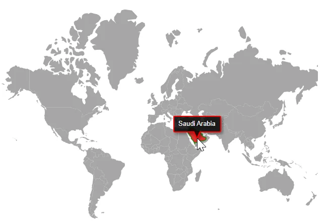
A tooltip displays additional information about a polygon shape during mouse or touch interaction. Enable the tooltip or tooltip template by setting the Visible property to true in MapsPolygonTooltipSettings. Additionally, set the desired content to the TooltipText property in the MapsPolygon tag to show the tooltip. When multiple polygon shapes are added, the TooltipText property can be set for each polygon to display the corresponding tooltip.
Tooltip customization
The following properties in MapsPolygonTooltipSettings customize the appearance of the tooltip.
- Fill - Applies the tooltip background color.
- BorderColor - Changes the tooltip border color.
- BorderWidth - Changes the tooltip border width.
- BorderOpacity - Changes the tooltip border opacity.
- FontFamily - Changes the tooltip text font family.
- FontWeight - Changes the tooltip text weight.
- FontStyle - Changes the tooltip text style.
- FontColor - Changes the tooltip text color.
- FontSize - Changes the tooltip text size.
- FontOpacity - Changes the tooltip text opacity.
@using Syncfusion.Blazor.Maps

<SfMaps>
    <MapsLayers>
        <MapsLayer ShapeData='new {dataOptions= "https://cdn.syncfusion.com/maps/map-data/world-map.json"}' TValue="string">
            <MapsPolygons>
                <MapsPolygon Points="Points" Fill="red" TooltipText="Saudi Arabia" Opacity="0.7" BorderColor="green" BorderWidth="2" BorderOpacity="0.7">
                </MapsPolygon>
                <MapsPolygonTooltipSettings Visible="true" BorderColor="Red" BorderWidth="2">
                </MapsPolygonTooltipSettings>
            </MapsPolygons>
        </MapsLayer>
    </MapsLayers>
</SfMaps>

@code {
    List<Coordinate> Points = new List<Coordinate>();

    protected override async Task OnInitializedAsync()
    {
        await base.OnInitializedAsync();
        Points.Add(new Coordinate() { Longitude = 34.88539587371454, Latitude = 28.181421087099537 });
        Points.Add(new Coordinate() { Longitude = 37.50029619722466, Latitude = 24.299419888989462 });
        Points.Add(new Coordinate() { Longitude = 39.22241423764024, Latitude = 22.638529461838658 });
        Points.Add(new Coordinate() { Longitude = 38.95650769309776, Latitude = 21.424998160017495 });
        Points.Add(new Coordinate() { Longitude = 40.19963938650778, Latitude = 20.271205391339606 });
        Points.Add(new Coordinate() { Longitude = 41.76547269134551, Latitude = 18.315451049867193 });
        Points.Add(new Coordinate() { Longitude = 42.78452077838921, Latitude = 16.097235052947966 });
        Points.Add(new Coordinate() { Longitude = 43.36984949591576, Latitude = 17.188572054533054 });
        Points.Add(new Coordinate() { Longitude = 44.12558191797012, Latitude = 17.407258102232234 });
        Points.Add(new Coordinate() { Longitude = 46.69027032797584, Latitude = 17.33342243475734 });
        Points.Add(new Coordinate() { Longitude = 47.09312386141585, Latitude = 16.97087769526452 });
        Points.Add(new Coordinate() { Longitude = 48.3417299826302, Latitude = 18.152700711188004 });
        Points.Add(new Coordinate() { Longitude = 49.74762591400318, Latitude = 18.81544363931681 });
        Points.Add(new Coordinate() { Longitude = 52.41428026336621, Latitude = 18.9035706497573 });
        Points.Add(new Coordinate() { Longitude = 55.272683129240335, Latitude = 20.133861012918544 });
        Points.Add(new Coordinate() { Longitude = 55.60121336079203, Latitude = 21.92042703112351 });
        Points.Add(new Coordinate() { Longitude = 55.08204399107967, Latitude = 22.823302662258882 });
        Points.Add(new Coordinate() { Longitude = 52.743894337844154, Latitude = 22.954463486477437 });
        Points.Add(new Coordinate() { Longitude = 51.47035908651375, Latitude = 24.35818837668566 });
        Points.Add(new Coordinate() { Longitude = 51.122553219055874, Latitude = 24.666679732426346 });
        Points.Add(new Coordinate() { Longitude = 51.58731671256831, Latitude = 25.173806925822717 });
        Points.Add(new Coordinate() { Longitude = 51.35950585992913, Latitude = 25.84556484481108 });
        Points.Add(new Coordinate() { Longitude = 51.088770529661275, Latitude = 26.168494193631147 });
        Points.Add(new Coordinate() { Longitude = 50.78527056538036, Latitude = 25.349051242147596 });
        Points.Add(new Coordinate() { Longitude = 50.88330288802666, Latitude = 24.779242606720743 });
        Points.Add(new Coordinate() { Longitude = 50.19702490702369, Latitude = 25.66825106363693 });
        Points.Add(new Coordinate() { Longitude = 50.066461167339924, Latitude = 26.268905608606616 });
        Points.Add(new Coordinate() { Longitude = 49.645896067213215, Latitude = 27.15116474192905 });
        Points.Add(new Coordinate() { Longitude = 48.917371072320805, Latitude = 27.55738830340198 });
        Points.Add(new Coordinate() { Longitude = 48.3984720209192, Latitude = 28.566207269716173 });
        Points.Add(new Coordinate() { Longitude = 47.68851714518985, Latitude = 28.5938991332588 });
        Points.Add(new Coordinate() { Longitude = 47.45059089191449, Latitude = 29.009321449856984 });
        Points.Add(new Coordinate() { Longitude = 44.73549453609391, Latitude = 29.157358362696385 });
        Points.Add(new Coordinate() { Longitude = 41.79487372890989, Latitude = 31.23489959729713 });
        Points.Add(new Coordinate() { Longitude = 40.36977176033773, Latitude = 31.9642352513131 });
        Points.Add(new Coordinate() { Longitude = 39.168270913149826, Latitude = 32.18348471414393 });
        Points.Add(new Coordinate() { Longitude = 37.019253492546454, Latitude = 31.47710220862595 });
        Points.Add(new Coordinate() { Longitude = 37.99644645508337, Latitude = 30.4851028633376 });
        Points.Add(new Coordinate() { Longitude = 37.67756530485232, Latitude = 30.3636358598429 });
        Points.Add(new Coordinate() { Longitude = 37.50181466030105, Latitude = 29.960155516804974 });
        Points.Add(new Coordinate() { Longitude = 36.700288181129594, Latitude = 29.882136586478993 });
        Points.Add(new Coordinate() { Longitude = 36.100009274845206, Latitude = 29.15308642012721 });
        Points.Add(new Coordinate() { Longitude = 34.85774476486728, Latitude = 29.3103032832622 });
        Points.Add(new Coordinate() { Longitude = 34.64498583263142, Latitude = 28.135787235699823 });
        Points.Add(new Coordinate() { Longitude = 34.88539587371454, Latitude = 28.181421087099537 });
    }
}
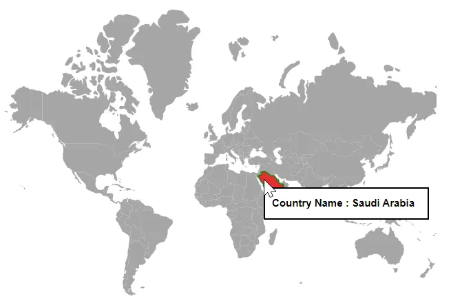
Tooltip template
Any HTML element can be rendered in the tooltip of polygon shapes using the TooltipTemplate property of MapsPolygon. When multiple polygon shapes are added, the TooltipTemplate property can be set for each polygon to display the corresponding tooltip.
@using Syncfusion.Blazor.Maps

<SfMaps>
    <MapsLayers>
        <MapsLayer ShapeData='new {dataOptions= "https://cdn.syncfusion.com/maps/map-data/world-map.json"}' TValue="string">
            <MapsPolygons>
                <MapsPolygon Points="Points" Fill="red" Opacity="0.7" BorderColor="green" BorderWidth="2" BorderOpacity="0.7">
                    <TooltipTemplate> <div style="width:240px;border: 2px solid #000;padding: 10px;background-color:white;color:black;font-weight:bold;font-size:15px;"> Country Name : Saudi Arabia</div> </TooltipTemplate>
                </MapsPolygon>
                <MapsPolygonTooltipSettings Visible="true"></MapsPolygonTooltipSettings>
            </MapsPolygons>
        </MapsLayer>
    </MapsLayers>
</SfMaps>

@code {
    List<Coordinate> Points = new List<Coordinate>();
    protected override async Task OnInitializedAsync()
    {
        await base.OnInitializedAsync();
        Points.Add(new Coordinate() { Longitude = 34.88539587371454, Latitude = 28.181421087099537 });
        Points.Add(new Coordinate() { Longitude = 37.50029619722466, Latitude = 24.299419888989462 });
        Points.Add(new Coordinate() { Longitude = 39.22241423764024, Latitude = 22.638529461838658 });
        Points.Add(new Coordinate() { Longitude = 38.95650769309776, Latitude = 21.424998160017495 });
        Points.Add(new Coordinate() { Longitude = 40.19963938650778, Latitude = 20.271205391339606 });
        Points.Add(new Coordinate() { Longitude = 41.76547269134551, Latitude = 18.315451049867193 });
        Points.Add(new Coordinate() { Longitude = 42.78452077838921, Latitude = 16.097235052947966 });
        Points.Add(new Coordinate() { Longitude = 43.36984949591576, Latitude = 17.188572054533054 });
        Points.Add(new Coordinate() { Longitude = 44.12558191797012, Latitude = 17.407258102232234 });
        Points.Add(new Coordinate() { Longitude = 46.69027032797584, Latitude = 17.33342243475734 });
        Points.Add(new Coordinate() { Longitude = 47.09312386141585, Latitude = 16.97087769526452 });
        Points.Add(new Coordinate() { Longitude = 48.3417299826302, Latitude = 18.152700711188004 });
        Points.Add(new Coordinate() { Longitude = 49.74762591400318, Latitude = 18.81544363931681 });
        Points.Add(new Coordinate() { Longitude = 52.41428026336621, Latitude = 18.9035706497573 });
        Points.Add(new Coordinate() { Longitude = 55.272683129240335, Latitude = 20.133861012918544 });
        Points.Add(new Coordinate() { Longitude = 55.60121336079203, Latitude = 21.92042703112351 });
        Points.Add(new Coordinate() { Longitude = 55.08204399107967, Latitude = 22.823302662258882 });
        Points.Add(new Coordinate() { Longitude = 52.743894337844154, Latitude = 22.954463486477437 });
        Points.Add(new Coordinate() { Longitude = 51.47035908651375, Latitude = 24.35818837668566 });
        Points.Add(new Coordinate() { Longitude = 51.122553219055874, Latitude = 24.666679732426346 });
        Points.Add(new Coordinate() { Longitude = 51.58731671256831, Latitude = 25.173806925822717 });
        Points.Add(new Coordinate() { Longitude = 51.35950585992913, Latitude = 25.84556484481108 });
        Points.Add(new Coordinate() { Longitude = 51.088770529661275, Latitude = 26.168494193631147 });
        Points.Add(new Coordinate() { Longitude = 50.78527056538036, Latitude = 25.349051242147596 });
        Points.Add(new Coordinate() { Longitude = 50.88330288802666, Latitude = 24.779242606720743 });
        Points.Add(new Coordinate() { Longitude = 50.19702490702369, Latitude = 25.66825106363693 });
        Points.Add(new Coordinate() { Longitude = 50.066461167339924, Latitude = 26.268905608606616 });
        Points.Add(new Coordinate() { Longitude = 49.645896067213215, Latitude = 27.15116474192905 });
        Points.Add(new Coordinate() { Longitude = 48.917371072320805, Latitude = 27.55738830340198 });
        Points.Add(new Coordinate() { Longitude = 48.3984720209192, Latitude = 28.566207269716173 });
        Points.Add(new Coordinate() { Longitude = 47.68851714518985, Latitude = 28.5938991332588 });
        Points.Add(new Coordinate() { Longitude = 47.45059089191449, Latitude = 29.009321449856984 });
        Points.Add(new Coordinate() { Longitude = 44.73549453609391, Latitude = 29.157358362696385 });
        Points.Add(new Coordinate() { Longitude = 41.79487372890989, Latitude = 31.23489959729713 });
        Points.Add(new Coordinate() { Longitude = 40.36977176033773, Latitude = 31.9642352513131 });
        Points.Add(new Coordinate() { Longitude = 39.168270913149826, Latitude = 32.18348471414393 });
        Points.Add(new Coordinate() { Longitude = 37.019253492546454, Latitude = 31.47710220862595 });
        Points.Add(new Coordinate() { Longitude = 37.99644645508337, Latitude = 30.4851028633376 });
        Points.Add(new Coordinate() { Longitude = 37.67756530485232, Latitude = 30.3636358598429 });
        Points.Add(new Coordinate() { Longitude = 37.50181466030105, Latitude = 29.960155516804974 });
        Points.Add(new Coordinate() { Longitude = 36.700288181129594, Latitude = 29.882136586478993 });
        Points.Add(new Coordinate() { Longitude = 36.100009274845206, Latitude = 29.15308642012721 });
        Points.Add(new Coordinate() { Longitude = 34.85774476486728, Latitude = 29.3103032832622 });
        Points.Add(new Coordinate() { Longitude = 34.64498583263142, Latitude = 28.135787235699823 });
        Points.Add(new Coordinate() { Longitude = 34.88539587371454, Latitude = 28.181421087099537 });
    }
}
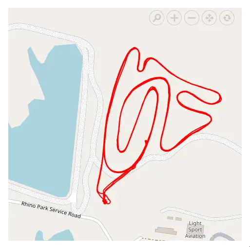
Changing a Polygon Shape to a Line
A rendered polygon shape can be changed to a line shape by setting the ShapeType property to LineString.
The following example demonstrates how to customize a line shape on an online map, display a tooltip for the line shape, highlight it, and select it on the map. In this example, latitude and longitude values are extracted from coordinates in a JSON file and assigned to the Points property within the MapsPolygon tag.
@using Syncfusion.Blazor.Maps
@inject NavigationManager NavigationManager
@inject HttpClient Http;
@using Newtonsoft.Json;

@if(Coordinates != null)
{
    <SfMaps>
        <MapsCenterPosition Latitude="-25.829397669018562" Longitude="28.539912753179671"></MapsCenterPosition>
        <MapsZoomSettings Enable="true" MinZoom="1" MaxZoom="19" ZoomFactor="17">
            <MapsZoomToolbarSettings>
                <MapsZoomToolbarButton ToolbarItems="new List<ToolbarItem>() { ToolbarItem.Zoom, ToolbarItem.ZoomIn, ToolbarItem.ZoomOut,
            ToolbarItem.Pan, ToolbarItem.Reset }"></MapsZoomToolbarButton>
            </MapsZoomToolbarSettings>
        </MapsZoomSettings>
        <MapsLayers>
            <MapsLayer UrlTemplate="https://tile.openstreetmap.org/level/tileX/tileY.png" TValue="string">
                <MapsPolygons>
                    <MapsPolygon Fill="transparent" BorderColor="red" Points="@Coordinates" TooltipText="Line String" BorderWidth="2" ShapeType="PolygonShapeType.LineString">
                    </MapsPolygon>
                    <MapsPolygonTooltipSettings Visible="true" BorderColor="Red" BorderWidth="1">
                    </MapsPolygonTooltipSettings>
                    <MapsPolygonHighlightSettings Enable=true Fill="yellow" Opacity="0.4">
                        <MapsPolygonHighlightBorder Color="blue" Opacity="1" Width="1"></MapsPolygonHighlightBorder>
                    </MapsPolygonHighlightSettings>
                    <MapsPolygonSelectionSettings Enable=true EnableMultiSelect=false Fill="violet" Opacity="0.8">
                        <MapsPolygonSelectionBorder Color="cyan" Opacity="1" Width="1"></MapsPolygonSelectionBorder>
                    </MapsPolygonSelectionSettings>
                </MapsPolygons>
            </MapsLayer>
        </MapsLayers>
    </SfMaps>
}

@code {
    public List<Coordinate> Coordinates = new List<Coordinate>();

    protected override async Task OnInitializedAsync()
    {
        string path = NavigationManager.BaseUri + "line.json";
        HttpClient httpClient = new HttpClient();
        string response = await Http.GetStringAsync(path);
        GeoJson shapeData = JsonConvert.DeserializeObject<GeoJson>(response);
        for (int i = 0; i < shapeData.Features[0].Geometry.Coordinates.Count; i++)
        {
            List<double> coordinate = shapeData.Features[0].Geometry.Coordinates[i];
            Coordinates.Add(new Coordinate() { Longitude = coordinate[0], Latitude = coordinate[1] });
        }
    }

    public class GeoJson
    {
        public string Type { get; set; }
        public List<Feature> Features { get; set; }
    }

    public class Feature
    {
        public string Type { get; set; }
        public Geometry Geometry { get; set; }
        public object Properties { get; set; }
    }

    public class Geometry
    {
        public string Type { get; set; }
        public List<List<double>> Coordinates { get; set; }
    }
}
Note: Refer to the content of the JSON file line.json.